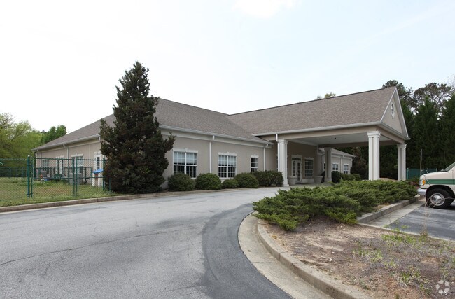
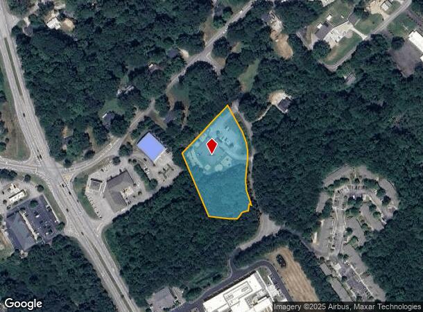
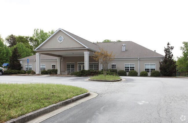
Property Record
122 Gabriel Cir, Gainesville, GA 30501

NEARBY LISTINGS FOR SALE OR LEASE
Property Detail
122 Gabriel Cir
Gainesville, GA
Larry S Davies Teresa A Davies
09-00125-00-068
WINN DIXIE DRIVE
Daycare
Hall
X
Georgia
13139C0183G
125
2025
2.47 AC
2025
Gainesville/Hall Cnty
000602
Atlanta
8,000 SF
DEMOGRAPHICS near 122 Gabriel Cir
1 Mile
3 Mile
5 Mile
2024 Total Population
4,099
26,500
61,761
2029 Population
4,521
29,339
68,269
Pop Growth 2024-2029
+ 10.30%
+ 10.71%
+ 10.54%
Average Age
41
39
37
2024 Total Households
1,621
10,023
21,765
HH Growth 2024-2029
+ 10.43%
+ 10.67%
+ 10.52%
Median Household Inc
$58,819
$54,984
$56,054
Avg Household Size
2.40
2.50
2.70
2024 Avg HH Vehicles
2.00
2.00
2.00
Median Home Value
$310,177
$284,798
$265,290
Median Year Built
1992
1982
1987
Nearby Places
Map Layers
Map Styles
 Street
 Aerial
- Restaurants
- Banks
- Shops
- Fitness
- Groceries
PUBLIC TRANSPORTATION
COMMUTER RAIL
Gainesville Amtrak Station (Crescent - Amtrak)
DRIVE
WALK
Distance
Gainesville Amtrak Station (Crescent - Amtrak)
8 min
4.1 mi
Freight Ports
Georgia Ports - Savannah
DRIVE
WALK
Distance
Georgia Ports - Savannah
322 min
254.6 mi
Nearby Properties
Address
Land Use
TOTAL SIZE
Lot Size
Zoning
Address
Land Use
TOTAL SIZE
Lot Size
Zoning
564,132 SF
48.45 AC
PUD
Address
Land Use
TOTAL SIZE
Lot Size
Zoning
34,131 SF
80.82 AC
L-I
Address
Land Use
TOTAL SIZE
Lot Size
Zoning
39,637 SF
31.55 AC
R-II
Address
Land Use
TOTAL SIZE
Lot Size
Zoning
27,221 SF
2.23 AC
G-B
Address
Land Use
TOTAL SIZE
Lot Size
Zoning
2,160 SF
5.60 AC
PUD
Address
Land Use
TOTAL SIZE
Lot Size
Zoning
44,052 SF
19.19 AC
PUD
Address
Land Use
TOTAL SIZE
Lot Size
Zoning
58,020 SF
3.15 AC
PUD
Address
Land Use
TOTAL SIZE
Lot Size
Zoning
237,470 SF
155.08 AC
L-I
Address
Land Use
TOTAL SIZE
Lot Size
Zoning
100,864 SF
4.10 AC
PUD
Address
Land Use
TOTAL SIZE
Lot Size
Zoning
2,038 SF
20.92 AC
R-II
Address
Land Use
TOTAL SIZE
Lot Size
Zoning
77,333 SF
11.74 AC
PUD
Address
Land Use
TOTAL SIZE
Lot Size
Zoning
56,780 SF
16.78 AC
PUD
Address
Land Use
TOTAL SIZE
Lot Size
Zoning
76,726 SF
0.42 AC
C-B
Address
Land Use
TOTAL SIZE
Lot Size
Zoning
46,795 SF
17.38 AC
PUD
Address
Land Use
TOTAL SIZE
Lot Size
Zoning
102,317 SF
6.90 AC
PUD
Address
Land Use
TOTAL SIZE
Lot Size
Zoning
128,531 SF
13.32 AC
R-I
Address
Land Use
TOTAL SIZE
Lot Size
Zoning
148,619 SF
30.75 AC
O-I
Address
Land Use
TOTAL SIZE
Lot Size
Zoning
54,720 SF
32.52 AC
R-II
Address
Land Use
TOTAL SIZE
Lot Size
Zoning
1,441 SF
10.46 AC
PUD
Address
Land Use
TOTAL SIZE
Lot Size
Zoning
25,386 SF
30.22 AC
AR-1
Address
Land Use
TOTAL SIZE
Lot Size
Zoning
140,805 SF
3.74 AC
PUD
Address
Land Use
TOTAL SIZE
Lot Size
Zoning
4,032 SF
89.43 AC
R-I
Address
Land Use
TOTAL SIZE
Lot Size
Zoning
467,600 SF
38.17 AC
L-I
Address
Land Use
TOTAL SIZE
Lot Size
Zoning
63,571 SF
31.97 AC
PUD
Address
Land Use
TOTAL SIZE
Lot Size
Zoning
82,610 SF
13.68 AC
G-B
Address
Land Use
TOTAL SIZE
Lot Size
Zoning
1,628 SF
10.41 AC
PUD
Address
Land Use
TOTAL SIZE
Lot Size
Zoning
328,604 SF
10 AC
I-1
Address
Land Use
TOTAL SIZE
Lot Size
Zoning
60,062 SF
0.51 AC
C-B
Address
Land Use
TOTAL SIZE
Lot Size
Zoning
67,383 SF
1.68 AC
C-B
Address
Land Use
TOTAL SIZE
Lot Size
Zoning
231,966 SF
0.95 AC
C-B
The World's #1 Commercial Real Estate Marketplace
Connect with us
© 2025 CoStar Group
The information above has been obtained from sources believed reliable. While we do not doubt its accuracy we have not verified it and make no guarantee, warranty or representation about it. It is your responsibility to independently confirm its accuracy and completeness. Any projections, opinions, assumptions, or estimates used are for example only and do not represent the current or future performance of the property. The value of this transaction to you depends on tax and other factors which should be evaluated by your tax, financial, and legal advisors. You and your advisors should conduct a careful, independent investigation of the property to determine to your satisfaction the suitability of the property for your needs.